10 March 2026 · 10 min read
What Is GPS-Tracked Leaflet Delivery? How It Works and Why It Matters
For decades, leaflet distribution operated entirely on trust. You handed over your leaflets and your money, hoped the distributor actually delivered them, and had no way of knowing what really happened once they walked out the door.
That's changed completely.
GPS-tracked leaflet delivery means exactly what it sounds like: every step of the distribution process is recorded using GPS technology, giving you a digital map of where your distributor walked, when they were there, and-when combined with timestamped photos-proof of distribution that your leaflets actually went through letterboxes.
This isn't some futuristic concept. It's standard practice now, and any distributor who resists it is waving a red flag the size of a postcode.
Why GPS Tracking Became Essential
The technology is simpler than you might think, but the implementation details matter.
The Distributor's Perspective
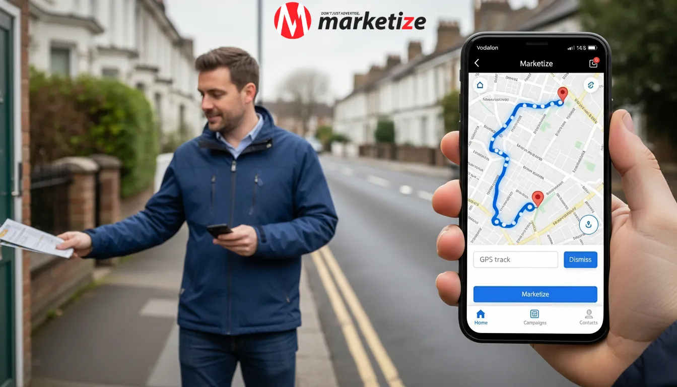
When a distributor accepts a job through a platform like Marketize, they download the app to their smartphone. Before starting distribution, they open the app and press "Start Tracking." From that moment, the phone records their GPS location continuously-typically every few seconds-as they move through the distribution area.
They walk their route, posting leaflets through letterboxes as they go. The app runs in the background, storing location data even when they're not actively looking at it. When they finish, they press "Complete," and the full route uploads to the platform.
What Gets Recorded
A GPS-tracked leaflet delivery captures several data points:
- Location trail: The exact path walked, recorded as a continuous line on a map. You see every street covered, every turn taken, every area reached.
- Timestamps: When distribution started, when it ended, and how long the distributor spent in each area. This helps verify whether the job was actually completed or whether someone rushed through unrealistically fast.
- Distance covered: Total walking distance, which should align logically with the number of properties in the area.
- Speed data: Average pace throughout the route. Industry benchmarks suggest 150-200 letterboxes per hour in high-density urban areas, 100-150 in suburban, 50-100 in rural. Significant deviations indicate potential issues.
Offline Storage and Real-Time Syncing
Here's where implementation matters. Some areas-particularly in rural locations or inside certain buildings--have patchy mobile signal. A GPS tracker that stops recording when signal drops creates gaps in the data.
Marketize's system stores GPS data locally on the phone when connection is unavailable, then syncs it automatically when signal returns. This eliminates blank spots on the route map. You get a complete picture regardless of signal quality during distribution.
Photo Verification Integration
GPS tracking tells you where someone walked. It doesn't prove they actually posted leaflets.
That's where photo verification comes in. Distributors can take timestamped, geo-stamped photos at intervals during distribution--typically every 50-100 letterboxes. These photos show the distributor's hand placing a leaflet into a letterbox or holding the leaflets at a recognizable location.
On platforms like Marketize, these photos appear as clickable icons directly on the GPS map. Click a pin, and you see the photo taken at that exact location and time. It's visual proof layered onto location proof.
What GPS Tracking Reveals (That Dishonest Distributors Can't Hide)
The beauty of GPS-tracked leaflet delivery is how it exposes patterns that previously went undetected.
Coverage Gaps
The most obvious issue: gaps in the route. If you specified a distribution area covering ten streets but the GPS shows they only walked seven, that's immediately visible. No arguments, no excuses-the data doesn't lie.
Selective Skipping
More subtle but equally problematic: distributors who walk the route but skip difficult properties. The GPS shows they walked the street, but when you compare the route to letterbox density data, the timing doesn't add up. They moved too fast, suggesting they skipped properties rather than delivering to every home.
Unrealistic Speed
Someone claiming to have delivered 5,000 leaflets in two hours should raise immediate suspicion. GPS data reveals exactly how long they were actually in the distribution area. If the timing suggests they'd need to be delivering 400+ leaflets per hour--physically impossible--you know something's wrong.
Route Logic
Did they actually cover the specified area, or did they wander into adjacent streets you didn't pay for? Did they follow a logical route that maximizes coverage, or does the GPS trail suggest they were just killing time?
All of this becomes visible with GPS-tracked leaflet delivery.
How It Protects Both Parties
This isn't just about catching dishonest distributors. It protects everyone involved.
For Clients
You know your money bought actual distribution. The GPS map and photos provide concrete evidence that your leaflets reached the intended area. If results are disappointing, you know it's not because distribution failed--it's something else (offer, design, timing, targeting). That clarity is valuable.
For Honest Distributors
Before GPS tracking, an honest distributor and a dishonest one looked identical to clients. Both collected leaflets, both claimed completion. The honest one had no way to prove their work beyond their word.
Now they do. The GPS trail is their defense against false accusations, their portfolio for attracting new clients, and their guarantee of payment through the platform's escrow-style system. Funds held by the platform only release upon verified completion-meaning GPS and photo proof must confirm the job was done properly.
If a client disputes completion, the platform reviews the GPS data, photos, and any communication logs as a neutral third party. The distributor doesn't need to argue their case or fear non-payment. The evidence speaks for itself.
For the Industry
GPS tracking has raised professional standards across the board. Distributors who refuse it look suspicious. Clients who don't require it look naive. It's become the baseline expectation rather than a premium add-on.
Understanding the Data: What to Look For
Once you've got GPS-tracked leaflet delivery data in front of you, what actually matters?
Route Completeness
Does the GPS trail cover your specified area fully? Compare the route to the distribution map you agreed on. Any missing streets should be addressed before you confirm completion - perhaps you did not order enough leaflets or the problem is of a different nature.
Timing Consistency
Check start and end times. Does the total duration make sense for the quantity delivered? A 1,000-leaflet job should take roughly 6-8 hours in suburban areas, 4-6 hours in high-density urban areas, 8-10+ hours in rural areas. Significant deviations either way need explanation.
Photo Distribution
Are photos spread evenly across the route, or clustered in one area? Even distribution suggests consistent work throughout. Clustering suggests potential issues-either the distributor took all photos at once or they encountered problems in certain areas that need discussion.
Letterbox Count Verification
Platforms like Marketize overlay letterbox counting data onto the GPS route. This compares the number of properties on streets actually walked against the quantity of leaflets the distributor claimed to deliver. If they walked streets containing 5,000 letterboxes but only collected 3,000 leaflets, something doesn't add up. Despite this, there will be margins of error and some minor discrepancies caused by letterbox counting, no junk mail, refusal by local residents which may cause some differences of 5-10%.
The 5% Reality: What GPS Can't Change
Even with perfect GPS tracking and honest distributors, roughly 5 - 10% of properties in any given area may be undeliverable. This is the reality on the ground.
Some homes display "No Junk Mail" signs. Others have secured entry systems with no way to access letterboxes. Some properties are temporarily vacant or under construction. Distributors aren't expected to ignore these signs or trespass to force delivery.
The 5% undeliverable allowance is industry-standard and should be factored into campaign planning. A 5,000-leaflet job might realistically deliver to 4,750 homes. GPS tracking doesn't change this--but it does show you why certain properties weren't reached, because the photos and notes from distributors can flag issues during the route.
GPS-Tracked Hand-to-Hand Distribution
While most commercial door to door leaflet distribution goes through letterboxes, some campaigns use hand-to-hand distribution in high-footfall public areas. GPS tracking applies here too, but slightly differently.
A distributor standing outside an Underground station entrance (on the public pavement--they can't go inside as stations are private property) for four hours has a GPS location that barely moves. That's expected. What matters is the timestamp showing they were there for the agreed duration and photos showing active distribution to pedestrians.
Distributors walking along a busy high street handing out leaflets show a GPS trail covering that street repeatedly over several hours. Again, this is normal and verifiable.
GPS-tracked leaflet delivery for hand-to-hand work proves the distributor was in the right location for the right duration. It can't prove exactly how many leaflets were handed out (some pedestrians decline), but it demonstrates they were actively working the agreed spot rather than abandoning it early.
Accessing and Using Your GPS Data
Most modern platforms make viewing real time GPS tracking data straightforward.
During Distribution
If you want, you can watch distribution happen in real-time. Log into your account and see the distributor's current location, the route they've covered so far, and how much remains. This is optional-many clients prefer to simply review everything once complete-but it's available if you're curious or want to check progress.
After Completion
Once the distributor marks the job complete, access the full distribution report. This typically includes:
- Complete GPS route map (every street walked)
- All timestamped, geo-stamped photos in a gallery
- Start and end times with total duration
- Distance covered
- Compliance summary (did they cover the specified area fully?)
You can download this data as PDF reports or export the raw GPS files if needed for your records.
Using It for Future Planning
GPS data from previous campaigns helps optimize future ones. If certain streets consistently took longer than expected, you'll know to adjust estimates. If particular areas showed gaps due to inaccessible properties, you can account for that in quantity planning. The data becomes a planning tool, more than just a verification tool.
What About Privacy?
A fair question: is it invasive to track someone's location constantly?
In commercial leaflet distribution service work, GPS tracking only operates during active jobs. Distributors start tracking when they begin distribution and stop it when they finish. The rest of their time isn't monitored. They're tracking their work, not their life.
This is standard practice across gig economy platforms. Delivery drivers, couriers, and field service workers have been GPS-tracked for years. It's not invasion of privacy, rather, it's work verification in a field-based job where there's no other way to confirm completion.
Distributors who refuse GPS tracking are essentially refusing to prove they did the work. The privacy concern as an excuse is a red flag.
The Trust Evolution
GPS-tracked leaflet delivery represents a fundamental shift in how this industry operates.
It transformed leaflet distribution from a black box into a transparent, verifiable process. Clients moved from hoping their leaflets got delivered to knowing they did. Honest distributors moved from competing with fraudsters to differentiating themselves through proven quality. The entire industry became measurably more professional.
Platforms like Marketize didn't invent GPS technology but smartphones made it accessible. They made it mandatory and integrated it properly: offline data storage, photo verification overlays, letterbox counting comparison, escrow-style payment protection, and neutral dispute resolution all built around GPS verification as the foundation.
The question for businesses planning leaflet campaigns isn't "Should we use GPS tracking?" It's "Why would we work with anyone who doesn't?"
For more on planning campaigns with GPS verification built in, Marketize's website offers detailed guides and resources covering everything from targeting to measurement. The technology is there. The transparency is real. The days of crossing your fingers and hoping for the best are over.